WeatherBlog

Tuesday, November 15, 2005

Global Ocean Analyses at 1/4 degrees

The MERCATOR group has recently launched a 0.25° global oceanical model. With such resolution, very nice depiction of oceanic phenomena can be obtained and satellite-derived sea surface temperatures can be used to validate!

See here for images of the various domains that the model PSY3V1 does forecasting for!


Monday, November 14, 2005

Kerry manuel: Gentleman and Hurricane guru

I have had the chance to meet Kerry Emanuel once at McGill University and I have had further contacts with him during my Masters as well. He's always proven helpful and willing to help. He has a personal FAQ on hurricanes, very interesting!
He also wrote a book, "Divine Winds: The History and Science of hurricanes" which would be a nice present for me! (hint hint)

Considered the expert on hurricanes on the thermodynamical point of view, he is one of few scientists who actually have designed their own theoretical framework in describing hurricanes. Does that make him a genius? Probably, but he's a "nice guy" before anything else.

As pointed out in a recent New York Times article, Emanuel insisted on the strong correlation between recent hurricanes intensification (Katrina, Rita,...) and an oceanographical feature called the loop current. The loop current maintains some warm sea surface temperature anomalies (i.e. warmer blobs of water) in the middle of the Gulf of Mexico, right along hurricane tracks.

Warm waters equal more energy to intensify from. That usually implies bad news along the way...

Monday, November 07, 2005

Hurricanes are here to stay...

... and get worse.

Global warming, whether discussed or not, is an almost absolute truth - yeah I realize I am taking sides.

Whether we talk about hurricane activity cycles or not, one thing is sure: we have had 3 Category 5 hurricanes this year of 2005 when the last three to occur were Ivan (2004), Mitch (1998) and, before that, you had to go back to 1992 with Andrew to find another! (Andrew was upgraded as a 10th bday present)

So what *IS* up? Well Katrina, Rita and Wilma. (girls I swear... Wilma being the strongest hurricane ever on record in the Atlantic Ocean at 882mb!).

If that wasn't enough, 2004 saw the first ever hurricane in the Southern Atlantic! (image courtesy of http://www.sat.dundee.ac.uk)
Yet another girl, Catarina hit unprepared Brazil on March 28, 2004 (which so happens to be the birthday of a good brazilian friend of mine!)


Things are getting worse. I suggest you do not retire in Florida...

Skeptics? Anyone? ;)

Tuesday, March 30, 2004

Square cloud!


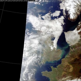
Off the coast of Denmark and the Netherlands, on march 30th 2004, the MODIS satellite captured this amazing cloud formation.

Yeah it's right: A SQUARE CLOUD!

How did it form? What atmospheric phenomenon keeps a straight line like this?

Add comments if you have a clue!